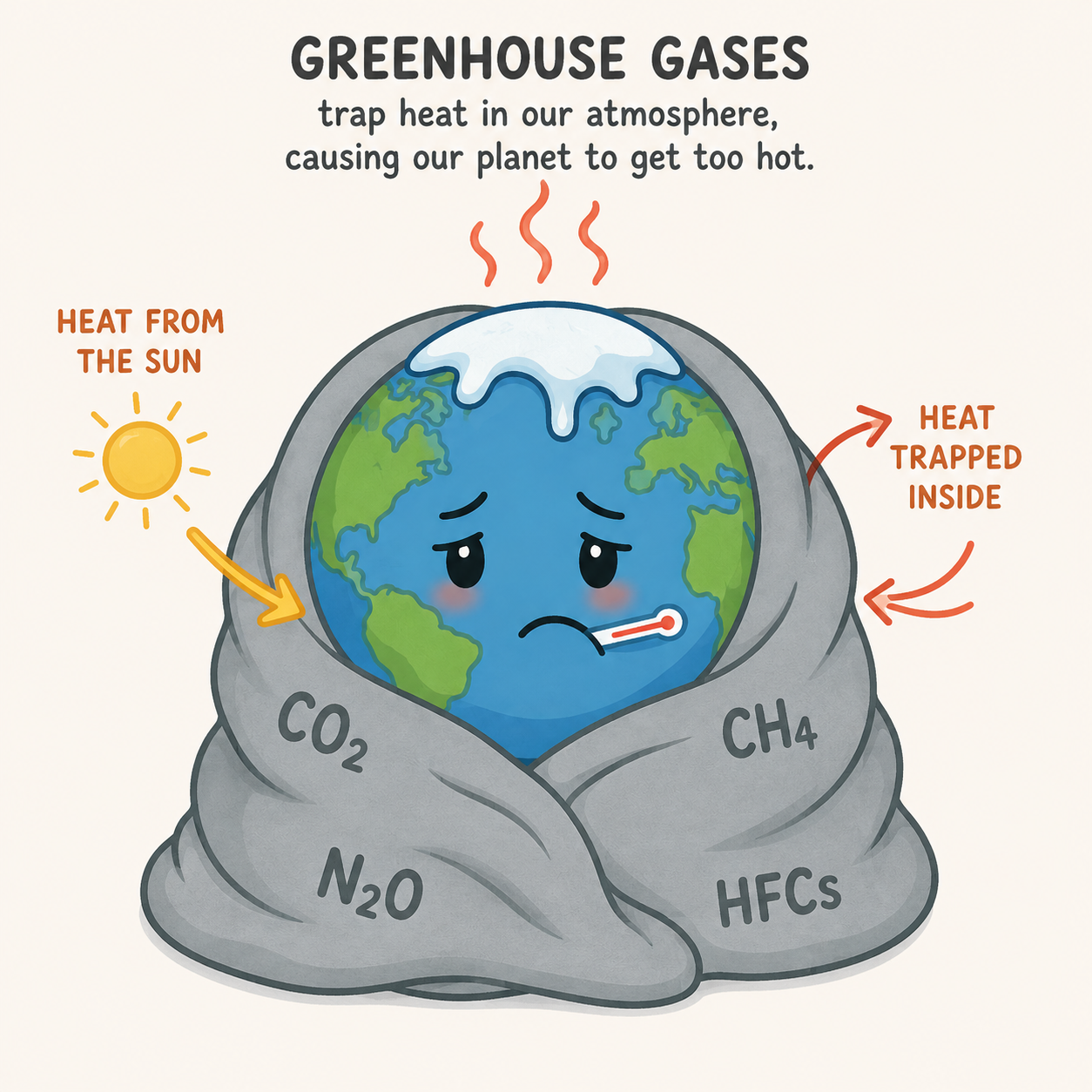
How Is the Climate Energy Hitting You?
The Jersey Shore Is Sure
New Jersey: The inverse barometer effect, wind stress, coastline shape, bathymetry, wave setup, tides, and storm track can combine to produce much larger water-level changes, resulting in extreme coastal flooding and saltwater intrusion. During major storms, observed water levels have reached roughly 9 feet above ground level along parts of the Jersey Shore and as much as 30 feet in parts of Florida.
Sea-Level Rise: Rubbing Salt in the Wound
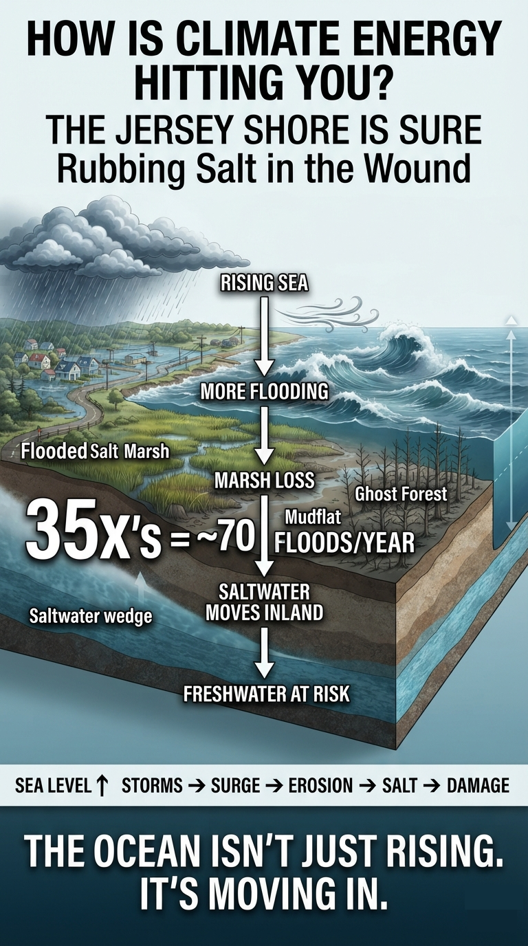
Sea-level rise is not simply a matter of the ocean getting higher. Climate change is altering the physical forces that move water toward and onto the shoreline. Rising seas, changing atmospheric pressure, stronger winds, altered ocean circulation, storm surge, king tides, and saltwater intrusion can interact to turn gradual sea-level rise into a much more immediate coastal threat.
A Real-World Warning: The Wetlands Institute
The experience of The Wetlands Institute in Stone Harbor, New Jersey, provides a striking example of how quickly coastal conditions can change.
The institute’s Salt Marsh Trail reportedly flooded only a few times a year around 2000. Over the past five years, flooding has averaged nearly 70 times annually. The institute is closing its headquarters on September 7, 2026, to begin a major coastal-resilience transformation.
The response includes raising the Salt Marsh Trail by two to three feet using clean dredged material, temporarily relocating operations and educational programs, and pursuing a broader campaign to replace and elevate the existing campus buildings.
This is more than an inconvenience. Increasingly frequent inundation can fundamentally alter the coastal ecosystem itself.
The Climate Shift
- Accelerated sea-level rise: Sea levels along parts of the New Jersey coast are rising faster than the global average.
- Marsh degradation: Repeated inundation can overwhelm salt-marsh vegetation, converting productive marsh into mudflats and eventually open water.
- Wildlife disruption: More frequent flooding threatens habitats used by marsh-dependent birds and can interfere with diamondback terrapin nesting.
- Infrastructure exposure: Roads, buildings, trails, drainage systems, and utilities face increasingly frequent flooding even without a major storm.
The critical point is that the climate signal is not experienced as a smooth, uniform rise in water level. It is experienced as more frequent encounters with water.
1. The Inverse Barometer Effect: Atmospheric Pressure Pushes the Ocean
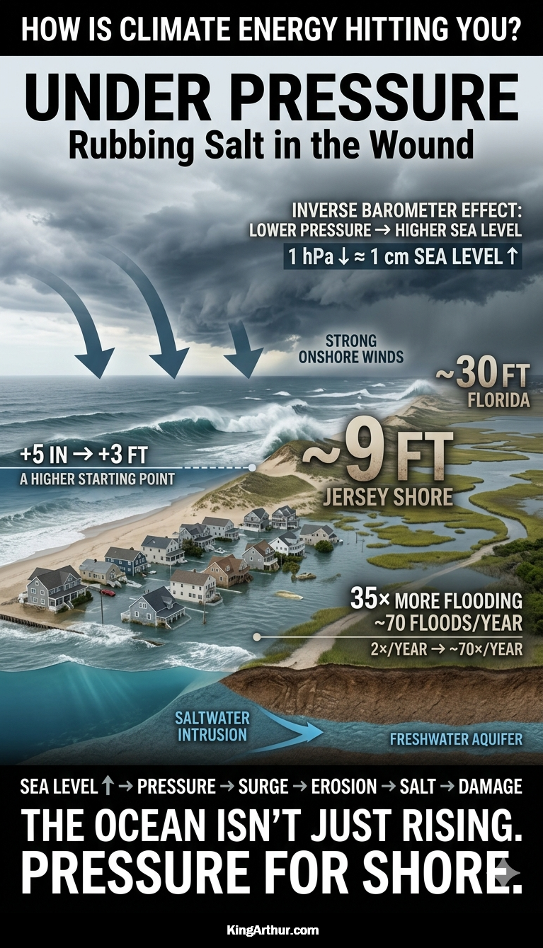
Atmospheric pressure exerts physical force on the ocean surface. When a deep low-pressure system moves over the coast, the reduced atmospheric weight allows the ocean surface to rise.
The approximate relationship is:
A 1-hectopascal (hPa) decrease in atmospheric pressure produces roughly a 1-centimeter rise in sea level.
A very deep storm can therefore raise the local ocean surface substantially before the effects of wind-driven storm surge are even considered.
This is known as the inverse barometer effect.
Climate change does not simply “raise the sea.” It can alter the atmospheric conditions that determine how that elevated ocean is distributed along the coastline at any particular moment.
Inverse Barometer Effect Examples
| Storm type | Approx. pressure near coast | Pressure drop from 1013 hPa | Inverse-barometer rise |
|---|---|---|---|
| Ordinary coastal storm | 990–1000 hPa | 13–23 hPa | 5–9 in |
| Strong nor’easter | 970–985 hPa | 28–43 hPa | 11–17 in |
| Very strong coastal storm | 950–965 hPa | 48–63 hPa | 19–25 in |
| Sandy-type extreme | ~945 hPa | ~68 hPa | ~27 in / 2.2 ft |
| Exceptional low-pressure event | 930–940 hPa | 73–83 hPa | 29–33 in / 2.4–2.8 ft |
The Combined Impact
The inverse barometer effect combines with wind stress, coastline shape, bathymetry, wave setup, tides, and storm track can produce much larger water-level changes. Hurricane Sandy’s actual coastal water levels were dramatically higher because the pressure effect was combined with enormous wind-driven surge, wave action, tide, and the storm’s exceptionally favorable track. At Sandy Hook, water reached about 8.9 feet above ground level, while the storm produced major surge throughout the central and northern Jersey Shore.
An additional 5 inches to 3 feet of sea-level rise represents a new baseline of climate energy impacting coastal communities. The inverse barometer effect then combines with wind stress, coastline shape, bathymetry, wave setup, tides, and storm track to produce much larger water-level changes. The result can be extreme coastal flooding, with observed water levels reaching roughly 9 feet above ground level along parts of the Jersey Shore and as much as 30 feet in parts of Florida during major storms.
2. Wind and Wave Energy: Turning Pressure Gradients Into Coastal Damage
Atmospheric pressure gradients—the differences between areas of high and low pressure—drive winds.
When those gradients become stronger, winds can become stronger and more persistent. Strong winds transfer energy to the ocean, generating larger waves and increasing wind setup, the piling of water against the coast.
The consequences can include:
- Higher water levels along exposed shorelines
- Larger and more destructive waves
- Increased dune erosion
- Offshore transport of beach sand
- Overtopping of coastal defenses
- Greater storm-surge penetration
The shoreline therefore experiences not only a higher baseline sea level but also increasingly energetic ways of moving that water around.
3. Altered Ocean Circulation: When Water Piles Up
Changes in large-scale atmospheric circulation can alter ocean currents and regional sea levels.
The relationship between the Gulf Stream, the North Atlantic circulation, winds, and coastal sea level is particularly important along the U.S. East Coast. Changes in ocean circulation can redistribute enormous volumes of water, producing dynamic sea-level changes that may differ substantially from the global average.
In simplified terms, when ocean circulation changes, water can accumulate against a coastline rather than being transported away from it.
That means a community can experience a rapid increase in local relative sea level even when the global mean is changing much more slowly.
4. Compound Coastal Flooding: When Everything Arrives Together
The most dangerous coastal flooding occurs when multiple processes reinforce one another.
Imagine a high tide occurring while:
- Global sea level is already elevated.
- A low-pressure storm raises the ocean through the inverse barometer effect.
- Strong onshore winds push additional water toward land.
- Large waves increase water levels and erode dunes.
- Heavy rainfall overwhelms drainage systems.
- Rivers are already elevated and cannot discharge efficiently.
These processes can combine into compound flooding.
The problem is not simply that the water is higher. The problem is that multiple pathways for moving water onto the land are operating simultaneously.
Salt marshes normally provide a natural buffer. But repeated inundation and erosion can eventually overwhelm the marsh itself. Once protective wetlands deteriorate, more wave energy reaches infrastructure, creating a feedback loop of increasing exposure and increasing damage.
Saltwater Intrusion: When the Ocean Moves Underground
Sea-level rise has another consequence that is much less visible than coastal flooding: saltwater intrusion.
Saltwater intrusion occurs when seawater moves into freshwater systems, including groundwater aquifers, rivers, wetlands, agricultural soils, and drinking-water supplies.
Two forces are especially important:
- Rising sea level increases the hydraulic pressure and inland reach of seawater.
- Drought and reduced groundwater recharge weaken the freshwater pressure pushing outward toward the sea.
Together, these forces can shift the boundary between freshwater and saltwater inland.
Research has projected that saltwater contamination could affect a very large proportion of coastal aquifers by 2100, although the extent varies substantially by geography, aquifer characteristics, groundwater use, and future climate conditions.
How the Saltwater Wedge Moves Inland
Under normal conditions, rainfall replenishes groundwater. Freshwater flows toward the coast and maintains a hydraulic gradient that helps resist seawater intrusion.
Because freshwater is less dense than seawater, a freshwater lens can exist above denser saltwater beneath coastal areas.
But the balance can shift.
1. Underground Aquifer Intrusion
As sea level rises, the hydraulic pressure exerted by seawater increases. At the same time, climate-driven drought and higher temperatures can reduce groundwater recharge in some regions.
Less freshwater flowing toward the ocean means less outward pressure resisting seawater.
The underground saltwater boundary can therefore migrate inland.
This process can occur largely out of sight until a well begins producing water with elevated salinity.
2. Surface and Vertical Infiltration
Storm surge, king tides, and coastal flooding can push seawater onto land.
If that water remains on the surface, it can infiltrate downward through soils and shallow geological formations, contaminating groundwater.
Repeated flooding is especially important because a single event may be temporary, while dozens of inundation events each year can progressively alter soil and groundwater chemistry.
3. The “Highway Effect”
Human modifications to coastal landscapes can provide pathways for seawater to travel inland.
Agricultural drainage ditches, shipping channels, tidal creeks, canals, and other engineered waterways can connect coastal waters with areas that were historically protected by natural terrain.
When sea level rises or storm surge moves inland, these channels can function as highways for saltwater.
The Ecological and Economic Consequences
Saltwater intrusion does not stop at the shoreline.
Ghost Forests
As saltwater enters coastal soils and groundwater, freshwater-dependent trees can die from prolonged salt stress. The result can be stands of dead trees known as ghost forests.
These landscapes provide visible evidence that the boundary between marine and terrestrial ecosystems is moving inland.
Agricultural Damage
Salt deposited on agricultural land can accumulate in the root zone.
Excessive soil salinity interferes with plants’ ability to absorb water and can reduce crop productivity. Persistent salinization can make valuable coastal farmland increasingly difficult—or eventually impossible—to farm without expensive remediation and freshwater management.
Infrastructure Corrosion
Saltwater and brackish groundwater are highly corrosive.
Repeated exposure can accelerate deterioration of underground pipes, electrical infrastructure, concrete, foundations, roads, and other infrastructure.
The damage can occur beneath the surface long before it becomes visually obvious.
Drinking-Water Threats
Coastal communities that depend on groundwater face a particularly serious vulnerability.
Pumping already lowers groundwater levels around wells. If the freshwater table is lowered too far, the hydraulic gradient resisting seawater intrusion weakens further.
This can create another feedback:
More pumping → lower freshwater pressure → greater saltwater intrusion → less usable freshwater.
The Larger Picture: Climate Energy Does Not Disappear
Sea-level rise is one expression of a much larger physical process.
The additional energy accumulating in the climate system does not simply produce a higher average temperature. Energy moves through the atmosphere, ocean, land, ice, and biosphere.
Along the coast, that energy can appear as:
Higher baseline sea level → more frequent tidal flooding → stronger storm impacts → erosion → wetland loss → saltwater intrusion → infrastructure damage → freshwater stress.
The critical distinction is between average conditions and actual events.
A few inches of average sea-level rise may sound modest. But those inches can determine whether a high tide remains below a road or flows across it. They can determine whether a storm surge is absorbed by a functioning marsh or reaches buildings and infrastructure.
The climate system does not deliver its additional energy evenly.
It delivers it through water, wind, waves, heat, storms, erosion, flooding, and ecological disruption.
And along the coast, the ocean is increasingly finding more ways to come ashore—and stay there.
Taking the Temperature of Climate Change: How Is Climate Energy Hitting You?
Easy-to-Read Resources